How might your neighborhood change by 2050?
Clark geospatial team developing AI technology to predict land cover changes due to population, economic, and climate scenarios
You spot an affordable house for sale in the country, miles away from the suburban sprawl. It’s your dream home, a classic New England cape abutting a patch of woods, with views of the river and extensive farm fields. And there’s not another house in sight.
You think this is your chance to buy a house, but you wish you could see into the future. Will your dream home become surrounded by housing developments? Will the river ever flood your basement because of torrential rains?
What if, before you bought the house, you could predict how the landscape might change over the next 10 to 20 years?
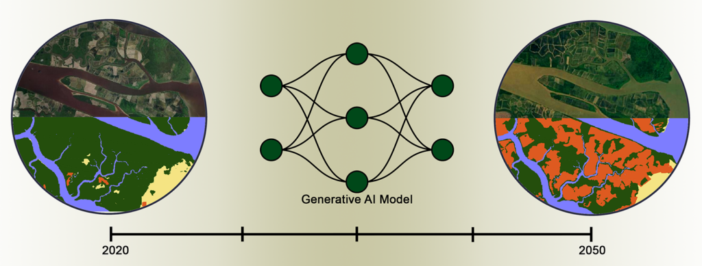
A research team at the Clark Center for Geospatial Analytics is developing a generative AI model to let you do just that. The team is led by Hamed Alemohammad, director of the center and associate professor in the Graduate School of Geography, part of the new School of Climate, Environment, and Society.
The generative AI model stems from a technological advancement developed by Alemohammad’s team, partnering with NASA and IBM, and released in 2023. The team created the Prithvi model, the world’s first geospatial AI foundation model, which scientists can use to build generative AI models customized for various applications instead of building such custom models from scratch. The AI foundation model saves researchers time and money by allowing them to access and study data more quickly and efficiently.
Building on the success of the Prithvi model, Alemohammad’s team is developing a new generative AI model that can indicate land cover changes over time.
“Anyone could prompt the AI model with potential scenarios like ‘What if the population increases by 20 percent?’ ”
— hamed alemohammad
Changes in land cover, Alemohammad explains, are driven by external factors such as population increase, which can spur demand for housing, resulting in conversion of natural land for development; economic growth, increasing demand for land to establish manufacturing plants; and changes in average rainfall, resulting in flooding or extensive vegetation growth, such as invasive grasses that fuel wildfires.

“These factors can impact the landscape on varying timescales, which might be from one to two years, to one to two decades,” he says.
With the new tool, citizens and policymakers will be able to predict future land cover changes by inputting scenarios for population, economic growth, and climate change, Alemohammad says.
“The AI model will be able to learn patterns of change in historical land cover data and generate future scenarios of land cover change,” he says. Once completed and made available to the public, “anyone could prompt the AI model with potential scenarios like ‘What if the population increases by 20 percent?’ and ask the model to predict the land cover in an area.”
For decision makers, for example, the AI model could generate maps to demonstrate the impact of certain policies or regulations and guide them through impact assessment, he says. For citizens, it could be a simple but powerful tool to imagine how their neighborhood might change under certain circumstances.
Funded by Taylor Geospatial Institute and Amazon Web Services (AWS), the research team is collaborating with Nathan Jacobs, professor in the Department of Computer Science and Engineering at Washington University in St. Louis. Taylor Geospatial and AWS are sponsoring the Generative AI for Geospatial Challenge, which, according to the organizations, “will bring together scientists, innovators, industry leaders, and the largest cloud resources to explore and expand the art of the possible for big-impact applications using geospatial data.” Last fall, at the challenge’s kickoff in St. Louis, Alemohammad spoke as part of a panel on “The Future of Geospatial Generative AI through the Lens of Industry and Research.” The challenge awarded $1 million in AWS credits, of which the Clark team received $100,000 in credits.
The AI model — under development as part of the challenge — represents a significant leap forward in the technology used by researchers over the past three decades to map land cover at regional and global scales, according to Alemohammad.
Until now, researchers have used satellite data, coupled with knowledge from experts working in the field, to create maps that help decision makers understand, for example, how agricultural lands have changed and how that might affect food production, or to monitor coastal erosion due to sea level rise and potential risks to coastal communities.
“While such maps provide valuable information about how the landscape has changed in the past, they don’t directly provide information about potential future changes,” Alemohammad says. “Having access to such information is critical to assess risks associated with these changes, and implementation of interventions to mitigate those risks.”


Copyright © 2024 Clark University
Public Information
|
Privacy Policy
|
Website Accessibility
|
Nondiscrimination Policy